
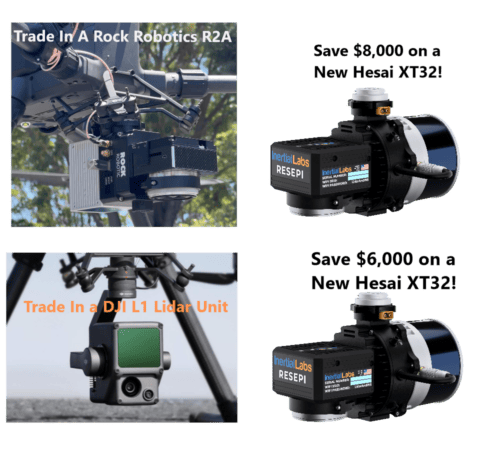
Unprecedented savings by upgrading your current L1 or R2A (Livox Avia) lidar system!
Call (800) 955-3960
Email for more information at info@atlanticlaserscanning.com
Test our Hesai XT32 RESEPI Lidar Unit!
Are you considering venturing into the realm of drone lidar technology? Do you wish to thoroughly evaluate lidar drone systems before making a commitment? Look no further, because Atlantic Laser Scanning Services(ALSS) has designed the perfect program tailored to your needs.
With our Lidar Rent-to-Purchase path, you can now rent our state-of-the-art Inertial Labs RESEPI Hesai XT32 lidar kit, complete with a laptop and processing software. This comprehensive package allows you to conduct an in-depth evaluation of the system for your specific project. But that’s not all! If you want to assess the system’s compatibility with a DJIM300 drone, ALSS also offers DJI M300 drones for rental, enabling you to evaluate the complete drone system.
For companies embarking on their initial foray into lidar survey data collection, ALSS even provides Emlid Base and Rover ground control systems available for rental. We understand that this technology may be new to you, and our aim is to make your experience as seamless as possible.
Whether you require the lidar unit for a couple of days, a week, or even longer, we want you to have sufficient time to assess its accuracy, functionality, and ease of use. At the end of the rental period, ifyou are convinced that the Hesai XT32 is the perfect fit for your requirements, ALSS will apply your entire rental fee directly towards the cost of purchasing a brand new Hesai XT32 unit. This means that you have nothing to lose and everything to gain!
To provide you with an example, let’s say you choose to rental Hesai XT32 RESEPI Lidar kit for one week at $2,500. Upon completing the rental, this amount will be subtracted from the total cost of a new Hesai XT32lidar unit, which is priced at $31,000. It’s important to note that your purchase order must be placed within 30 days of concluding the rental period.
We understand that delving into new technology can be intimidating, let ALSS help! Let our team of experts guide your staff through the basic workflow of setting up the lidar unit, collecting data, and processing it using the included software and laptop. Our expertly crafted instructional videos will provide invaluable assistance, ensuring a smooth transition into working with the lidar system. And if you encounter any technical questions or obstacles along the way, our knowledgeable experts will be there to guide you through the lidar workflow process, offering tailored solutions to meet your unique needs.
It’s worth mentioning that the data collected during your evaluation period belongs entirely to your company. You have the freedom to examine and test it extensively or, if you choose, to present it to your customer.
Atlantic Laser Scanning Services is committed to making the transition into drone lidar technology as effortless as possible. Our Lidar Rent-to-Purchase program provides you with the opportunity to thoroughly evaluate the Hesai XT32 lidar system and its capabilities before making a final decision. With the added benefit of applying your rental fee directly towards the purchase of a new unit, the value is undeniable. Embrace the future of lidar technology with confidence, and let ALSS be your trusted partner in this exciting journey. Contact us today to explore the possibilities!
Drone Lidar as an industry is exploding right now.
Uses from Survey work, TOPO, modeling, mapping and even visual effects work is driving up the need for more qualified data providers.
ALSS hears from 107 pilots, survey companies, and modeling companies who are looking to expand their companies services, and have questions about drone lidar.
We feel we offer the ideal scenario for customers looking to ease into the industry, or companies who know this is where they need to be, and are ready to buy.
That is the ALSS Rent to Purchase track.
Simply put, if you have a 107 qualified pilot on staff, ALSS has everything you would need to evaluate the Lidar equipment.
If you currently have commercial drones? and Ground control GNSS equipment? JUST RENT THE HESAI XT32 LIDAR UNIT
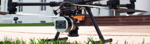
If you currently pilot smaller drones and work in survey, RENT A DJI M300 DRONE AND HESAI XT32 LIDAR UNIT
If you have a license but no experience or survey equipment, RENT SURVEY ACCESSORIES, AN EMLID BASE / ROVER SYSTEM, M300 DRONE, AND HESAI XT32 LIDAR UNIT
Regardless of the package you need, let our experts walk you through the workflow, along with our free YouTube workflow videos. Fly a simple project, and evaluate the workflow, equipment, and data. If you are comfortable with the process, continue to rent for any upcoming lidar projects?
If you are ready to buy, ALSS will put the entire lidar rental fee toward your purchase price!
Survey drone LiDAR units, such as the RESEPI Hesai Xt32, Velodyne, Livox, R2A, R360, and Ouster scanners, offer several advantages over standard survey techniques. Here are some of their uses and benefits:
1. Rapid Data Collection: Surveying large areas can be time-consuming and labor-intensive using traditional methods. LiDAR-equipped drones enable fast data acquisition by scanning large areas from above in a short period. This allows surveyors to cover more ground quickly and efficiently, reducing overall project timelines.
2. High-Resolution 3D Data: LiDAR scanners on survey drones capture millions of points per second, resulting in highly detailed and accurate 3D data. This level of precision allows for precise measurements, enabling better analysis, modeling, and decision-making in various industries.
3. Remote and Hazardous Area Mapping: Survey drones equipped with LiDAR can access remote or hazardous areas that are difficult or dangerous to reach on foot. This includes areas with rough terrain, dense vegetation, or limited accessibility. By collecting data from these challenging locations, surveyors can obtain comprehensive and accurate information without putting themselves at risk.
4. Improved Data Quality: LiDAR technology eliminates many of the limitations and errors associated with traditional survey techniques. The high accuracy and density of the collected point cloud data result in detailed and reliable representations of the surveyed area. This enhanced data quality leads to more precise measurements, improved modeling, and better-informed decision-making.
5. Multi-Sensor Integration: LiDAR units on survey drones can be integrated with other sensors, such as cameras and thermal imaging devices. This allows for simultaneous collection of additional data, such as high-resolution imagery, temperature readings, or multispectral data. By combining multiple data sources, surveyors can gain comprehensive insights and perform more in-depth analysis.
6. Cost and Time Savings: LiDAR-equipped drones offer significant cost and time savings compared to traditional survey methods. They require fewer personnel and equipment, as well as less time in the field. Additionally, the rapid data acquisition and processing capabilities of LiDAR scanners enable quicker decision-making and reduced project timelines.
7. Versatility and Scalability: LiDAR-equipped survey drones can be used in a wide range of industries and applications. They are suitable for topographic mapping, infrastructure inspections, construction monitoring, forestry management, mining, and more. Furthermore, the scalability of drone-based LiDAR technology allows for surveys of varying scales, from small sites to large-scale projects.
In summary, survey drone LiDAR units offer numerous advantages over standard survey techniques. They enable rapid data collection, provide high-resolution 3D data, access remote or hazardous areas, improve data quality, support multi-sensor integration, save costs and time, and offer versatility for various industries. Incorporating LiDAR technology into surveying workflows can enhance accuracy, efficiency, and overall project outcomes.
The FARO Focus 3D laser scanner is a versatile and powerful tool with numerous applications in various industries. Here are a few examples of its uses:
- BIM Modeling: Building Information Modeling (BIM) is a process that involves creating a digital representation of a building or infrastructure project. The FARO Focus 3D scanner can capture detailed 3D point clouds of existing structures, allowing architects, engineers, and construction professionals to create accurate as-built models. These models can be used for renovation projects, clash detection, facility management, and more.
- Forensic Engineering: In forensic engineering investigations, precise and comprehensive data collection is crucial. The FARO Focus 3D scanner can capture detailed information about accident scenes, structural failures, or crime scenes. By creating an accurate 3D representation, investigators can analyze and reconstruct events, measure distances, extract dimensions, and perform virtual walkthroughs. This data can be used for analysis, simulations, and presentations in legal proceedings.
- Visual Effects Studios: The entertainment industry, particularly visual effects studios, can benefit from the FARO Focus 3D scanner. It can capture high-resolution 3D data of real-world objects, environments, or actors, which can be used as references or to create digital assets. This technology helps in integrating computer-generated elements seamlessly into live-action footage, improving the overall realism and quality of visual effects in movies, TV shows, and video games.
- Architecture and Construction: Architects, engineers, and construction professionals can use the FARO Focus 3D scanner to accurately capture and document existing structures, construction sites, or heritage buildings. This data can be used for design visualization, clash detection, quality control, and progress monitoring. The scanner allows for faster and more accurate measurements compared to traditional surveying methods, reducing errors and rework.
- Industrial Facilities: The scanner’s portability and versatility make it suitable for capturing complex industrial environments, such as factories, refineries, or power plants. It can generate detailed 3D models of machinery, piping, equipment, and entire facilities. This information is valuable for plant layout planning, facility management, maintenance, and retrofitting.
Overall, the FARO Focus 3D laser scanner provides precise, efficient, and highly detailed 3D data capture, enabling a wide range of applications across industries, including BIM modeling, forensic engineering, visual effects, architecture, construction, and industrial facilities. Its ability to rapidly capture accurate measurements and create realistic 3D models makes it an indispensable tool for professionals seeking to enhance their workflows and improve project outcomes.